


lagardesept2016

brandy
User
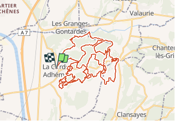

Length
34 km

Max alt
233 m

Uphill gradient
749 m
Km-Effort
44 km

Min alt
84 m

Downhill gradient
740 m
Boucle
Yes
Creation date :
2018-04-17 13:08:44.492
Updated on :
2018-04-17 13:08:44.492
--
Difficulty : Difficult

FREE GPS app for hiking
 SityTrail
IGN / Geographical institutes
SityTrail Plus
The world is yours!
About
Trail Mountain bike of 34 km to be discovered at Auvergne-Rhône-Alpes, Drôme, La Garde-Adhémar. This trail is proposed by brandy.
Positioning
Country:
France
Region :
Auvergne-Rhône-Alpes
Department/Province :
Drôme
Municipality :
La Garde-Adhémar
Location:
Unknown
Start:(Dec)
Start:(UTM)
639661 ; 4917161 (31T) N.
Comments